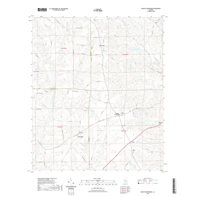
2020 Map of Danleys Crossroads
USGS Topo · Published 2020About this map
Danleys Crossroads sits at the convergence of rural routes in the northern reaches of Coffee County, where the landscape is defined by the headwaters of numerous creeks and scattered agricultural settlements. The terrain is marked by family-named landmarks and local burial grounds, including the Danley's Crossroads Cem and Friendship Community Cem near the Friendship community. Water management is a visible priority across the landscape, seen in the presence of County Lake, Whitman Pond, and Donaldson Pond. These features, along with the meandering courses of Lightwood Knot Cr and Beaverdam Cr, illustrate the drainage patterns of the coastal plain. The road network, including the curiously named Popcorn Ln and Old Boggy Rd, connects these small hamlets to the larger seat at Elba to the southeast, reflecting a century of rural development and land use across the tri-county border area of Crenshaw, Covington, and Coffee.
Find a feature on this map
88 named features on this map. Tap any name to fly to it.
Don’t see what you’re looking for? This feature index may not catch every label — zoom into the map to look around manually.
Map Details
Editions of this 2020 Danleys Crossroads Map
This is the sole edition of this map. No revisions or reprints were ever made.
Other maps of this area

1953 · Andalusia
USGS Topo · 1:250,000

1957 · Andalusia
USGS Topo · 1:250,000

1968 · Danleys Crossroads
USGS Topo · 1:24,000
1968 · Ino
USGS Topo · 1:24,000
1968 · Bluff Springs
USGS Topo · 1:24,000

1968 · Opp East
USGS Topo · 1:24,000
1968 · Elba
USGS Topo · 1:24,000

1968 · Bullock
USGS Topo · 1:24,000

1971 · Dozier
USGS Topo · 1:24,000

1971 · Brantley
USGS Topo · 1:24,000