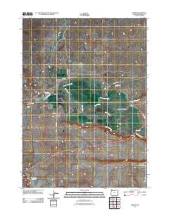
2011 Map of Danner
USGS Topo · Published 2011About this map
Danner sits at the heart of this high-desert ranching landscape in Malheur County, where water management and cattle operations define the terrain. The presence of several large, named estates such as Barrick and Shannon Ranch, Goose Ranch, and Skinner Ranch indicates a history of consolidated landholdings in the Danner Valley. The importance of water in this arid environment is evident in the engineered systems of the South Antelope Canal, Skinner Dam, and both the Antelope Reservoir and Rock Creek Reservoir. Transportation and logistics in this remote corner of Oregon are marked by long, unpaved routes like 3 Forks Rd and Anawalt Rd, as well as the private Skinner Ranch Airport, reflecting the isolation of these outposts. The map also captures the varied topography from the open valley to the steep descent of Jordan Creek Canyon.
Find a feature on this map
24 named features on this map. Tap any name to fly to it.
Don’t see what you’re looking for? This feature index may not catch every label — zoom into the map to look around manually.
Map Details
Editions of this 2011 Danner Map
This is the sole edition of this map. No revisions or reprints were ever made.
Other maps of this area

1955 · Jordan Valley
USGS Topo · 1:250,000

1955 · Boise
USGS Topo · 1:250,000

1957 · Jordan Valley
USGS Topo · 1:250,000

1958 · Boise
USGS Topo · 1:250,000

1958 · Jordan Valley
USGS Topo · 1:250,000

1962 · Boise
USGS Topo · 1:250,000
1969 · Little Grassy Mountain
USGS Topo · 1:24,000

1969 · Jordan Craters South
USGS Topo · 1:24,000
1969 · Juniper Ridge
USGS Topo · 1:24,000

1969 · Cow Lakes
USGS Topo · 1:24,000