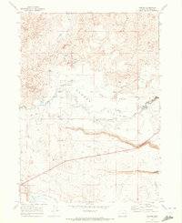
1969 Map of Danner
USGS Topo · Published 1973About this map
The Jean Baptiste Charbonneau Grave marks a site of significant historical interest near the small settlement of Danner, where the son of Sacagawea is interred. This 1969 survey of southeast Oregon captures a landscape where water management and ranching define the human presence. Significant infrastructure such as Skinner Dam and Palmer Dam control the flow of Jordan Creek, while the Goose Ranch and its nearby Landing Strip illustrate the remote nature of operations in Danner Valley. The topography is heavily influenced by volcanic history, with extensive lava fields dominating the northern section of the map and geological features like Rattlesnake Cave and the Jack Creek Hills rising above the flats. To the south, the terrain opens into Antelope Flat and Rock Creek Flat, bordering the waters of Antelope Reservoir.
Find a feature on this map
30 named features on this map. Tap any name to fly to it.
Don’t see what you’re looking for? This feature index may not catch every label — zoom into the map to look around manually.
Map Details
Editions of this 1969 Danner Map
This is the sole edition of this map. No revisions or reprints were ever made.
Other maps of this area

1955 · Jordan Valley
USGS Topo · 1:250,000

1955 · Boise
USGS Topo · 1:250,000

1957 · Jordan Valley
USGS Topo · 1:250,000

1958 · Boise
USGS Topo · 1:250,000

1958 · Jordan Valley
USGS Topo · 1:250,000

1962 · Boise
USGS Topo · 1:250,000
1969 · Little Grassy Mountain
USGS Topo · 1:24,000

1969 · Jordan Craters South
USGS Topo · 1:24,000
1969 · Juniper Ridge
USGS Topo · 1:24,000

1969 · Cow Lakes
USGS Topo · 1:24,000