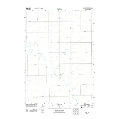
2012 Map of Dante
USGS Topo · Published 2012About this map
Dante and the surrounding plains of Charles Mix County are defined by a strictly surveyed grid of agricultural corridors and the meandering path of Choteau Cr. This 2012 survey illustrates the intersection of rural life and water management, featuring the central basin of Lake Dante and the quiet presence of the United Cem to the northeast. The landscape is organized by an extensive network of section-line roads, including 397th Ave and 300th St, which facilitate transport across this productive prairie region. The interplay between the natural drainage of the creek and the human-imposed geometry of the road system reflects the enduring agricultural character of south-central South Dakota.
Find a feature on this map
18 named features on this map. Tap any name to fly to it.
Don’t see what you’re looking for? This feature index may not catch every label — zoom into the map to look around manually.
Map Details
Editions of this 2012 Dante Map
This is the sole edition of this map. No revisions or reprints were ever made.
Other maps of this area

1955 · Mitchell
USGS Topo · 1:250,000

1955 · O'Neill
USGS Topo · 1:250,000

1959 · O'Neill
USGS Topo · 1:250,000

1959 · Mitchell
USGS Topo · 1:250,000

1964 · Wagner NE
USGS Topo · 1:24,000

1964 · Wagner
USGS Topo · 1:24,000

1964 · Lynch NE
USGS Topo · 1:24,000

1969 · O'Neill
USGS Topo · 1:250,000
1972 · Niobrara NW
USGS Topo · 1:24,000
1972 · Dante
USGS Topo · 1:24,000