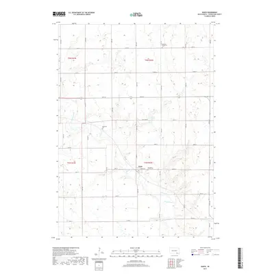
2017 Map of Dante
USGS Topo · Published 2017About this map
Dante stands as the central hub of this agricultural landscape in Charles Mix County, situated near the intersection of Warren Ave and 300th St. The town's social and community fabric is etched into the terrain through several burial grounds, including the Bohemian Presbyterian Cem to the north and Saint Mary's Catholic Cem just east of the village. These sites reflect the European immigrant heritage that settled the South Dakota plains. The drainage of Chateau Creek meanders through the township, providing a natural break in the geometric grid of section lines and gravel roads. North of the settlement, Lake Dante and the smaller Greenwood Cem offer further points of interest for those tracing the development of this rural prairie community.
Find a feature on this map
24 named features on this map. Tap any name to fly to it.
Don’t see what you’re looking for? This feature index may not catch every label — zoom into the map to look around manually.
Map Details
Editions of this 2017 Dante Map
This is the sole edition of this map. No revisions or reprints were ever made.
Other maps of this area

1955 · Mitchell
USGS Topo · 1:250,000

1955 · O'Neill
USGS Topo · 1:250,000

1959 · O'Neill
USGS Topo · 1:250,000

1959 · Mitchell
USGS Topo · 1:250,000

1964 · Wagner NE
USGS Topo · 1:24,000

1964 · Wagner
USGS Topo · 1:24,000

1964 · Lynch NE
USGS Topo · 1:24,000

1969 · O'Neill
USGS Topo · 1:250,000
1972 · Niobrara NW
USGS Topo · 1:24,000
1972 · Dante
USGS Topo · 1:24,000