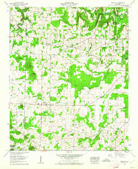
1960 Map of Danville
USGS Topo · Published 1961About this map
The boundary between Lawrence and Morgan Counties bisects this 1960 landscape, where the agricultural uplands of Danville meet the northern edges of the William B. Bankhead National Forest. This era in northern Alabama shows a mosaic of rural communities like Pumpkin Center and Neel, connected by a dense network of country roads serving numerous family-named cemeteries and small churches. The topography is defined by prominent elevations such as Owen Mountain and Isabel Mountain, which overlook the fertile bottomlands of Long Bottom.
Find a feature on this map
45 named features on this map. Tap any name to fly to it.
Don’t see what you’re looking for? This feature index may not catch every label — zoom into the map to look around manually.
Map Details
Editions of this 1960 Danville Map
3 editions found
Other maps of this area

1888 · Cullman
USGS Topo · 1:125,000

1888 · Huntsville
USGS Topo · 1:125,000

1892 · Cullman
USGS Topo · 1:125,000

1892 · Huntsville
USGS Topo · 1:125,000

1927 · Falkville
USGS Topo · 1:24,000

1935 · Upshaw
USGS Topo · 1:24,000

1935 · Danville
USGS Topo · 1:48,000

1935 · Oakville
USGS Topo · 1:24,000

1936 · Caddo
USGS Topo · 1:24,000

1936 · Mc Kendry
USGS Topo · 1:24,000