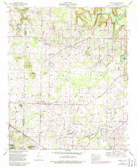
1960 Map of Danville
USGS Topo · Published 1989About this map
The community of Danville anchors this mid-century look at the borderlands between Lawrence and Morgan counties, just as the regional landscape was maturing under the influence of the Tennessee Valley Authority. To the northeast, the backwaters of Wheeler Lake reach into the drainage of Flint Creek, while the southwestern corner is defined by the protected timberlands of the William B Bankhead National Forest. This survey captures the rural character of the area through its dense network of small family-named cemeteries and country churches, such as Harmony Grove Ch and Upton Chapel.
Find a feature on this map
46 named features on this map. Tap any name to fly to it.
Don’t see what you’re looking for? This feature index may not catch every label — zoom into the map to look around manually.
Map Details
Editions of this 1960 Danville Map
3 editions found
Other maps of this area

1888 · Cullman
USGS Topo · 1:125,000

1888 · Huntsville
USGS Topo · 1:125,000

1892 · Cullman
USGS Topo · 1:125,000

1892 · Huntsville
USGS Topo · 1:125,000

1927 · Falkville
USGS Topo · 1:24,000

1935 · Upshaw
USGS Topo · 1:24,000

1935 · Danville
USGS Topo · 1:48,000

1935 · Oakville
USGS Topo · 1:24,000

1936 · Caddo
USGS Topo · 1:24,000

1936 · Mc Kendry
USGS Topo · 1:24,000