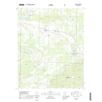
2020 Map of Danville
USGS Topo · Published 2020About this map
Danville serves as a primary hub in this Yell County landscape, situated where the Petit Jean River flows past the Yell County Danville Courthouse. The settlement pattern follows a clear east-west axis defined by the river and the Belleville Ridge, connecting the communities of Belleville and Corinth. The southern portion of the map is dominated by the northern reaches of the Ouachita National Forest, where the terrain rises sharply into Danville Mtn and Dutch Creek Mtn. Numerous family-named cemeteries, such as Thompson Cem, Lynch Cem, and Harris Cem, are scattered throughout the valley, providing significant points of interest for genealogical research. The area’s infrastructure is anchored by local aviation at Danville Municipal Airport and the Cedar Creek Ranch Airport, while the hydrology is characterized by a network of creeks and small lakes including Cowger Lake and Buckman Lake.
Find a feature on this map
98 named features on this map. Tap any name to fly to it.
Don’t see what you’re looking for? This feature index may not catch every label — zoom into the map to look around manually.
Map Details
Editions of this 2020 Danville Map
This is the sole edition of this map. No revisions or reprints were ever made.
Other maps of this area

1879 · Mountain Home
USGS Topo · 1:62,500

1887 · Magazine Mountain #4
USGS Topo · 1:62,500

1887 · Magazine Mountain
USGS Topo · 1:62,500

1888 · Dardanelle #3
USGS Topo · 1:62,500

1890 · Magazine Mountain
USGS Topo · 1:125,000

1890 · Mount Ida
USGS Topo · 1:125,000

1890 · Hot Springs
USGS Topo · 1:125,000

1890 · Dardanelle
USGS Topo · 1:125,000

1894 · Hot Springs
USGS Topo · 1:125,000

1955 · Little Rock
USGS Topo · 1:250,000