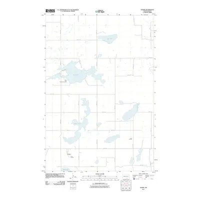
2011 Map of Danzig
USGS Topo · Published 2011About this map
Danzig anchors the southern landscape of this McIntosh County region, situated amidst a glacial prairie environment defined by scattered lake basins and a strict section-line road grid. The settlement is flanked by the Danzig Cemetery, while the more distant Salem Cemetery serves the rural population to the east. This 2011 survey documents a water-dominated geography, featuring the expansive Green Lake and its associated Green Lake Outlet Control Dam, which manages the local hydrology. Smaller bodies of water such as Clear Lake, Pudwill Lake, and Goose Lake are distributed across the township, illustrating the typical prairie pothole terrain of central North Dakota. The infrastructure is characterized by a precise network of rural routes, including 43rd Ave SE and 87th St SE, which provide access to the agricultural tracts and isolated water features that define the area's spatial organization.
Find a feature on this map
23 named features on this map. Tap any name to fly to it.
Don’t see what you’re looking for? This feature index may not catch every label — zoom into the map to look around manually.
Map Details
Editions of this 2011 Danzig Map
This is the sole edition of this map. No revisions or reprints were ever made.
Other maps of this area

1953 · Jamestown
USGS Topo · 1:250,000

1956 · Jamestown
USGS Topo · 1:250,000

1982 · Danzig
USGS Topo · 1:24,000

1982 · Ashley East
USGS Topo · 1:24,000

1982 · May Lake
USGS Topo · 1:24,000
1982 · May Lake SE
USGS Topo · 1:24,000

1982 · Ashley NE
USGS Topo · 1:24,000

1982 · Lehr SW
USGS Topo · 1:24,000
1982 · Ashley West
USGS Topo · 1:24,000

1982 · Wishek
USGS Topo · 1:24,000