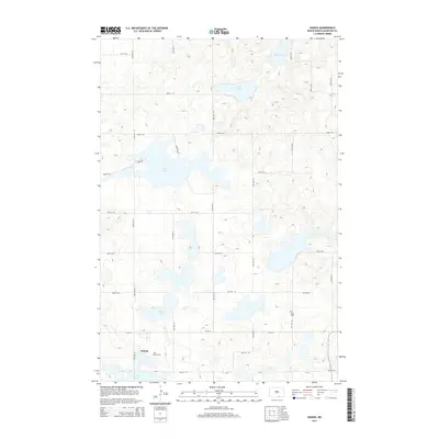
2014 Map of Danzig
USGS Topo · Published 2014About this map
Danzig sits in a glacial landscape defined by numerous prairie potholes and seasonal water bodies in McIntosh County. The map documents a predominantly agricultural grid system, where section lines are traced by routes like 85th St SE and 45th Ave SE. For those researching local heritage, the inclusion of Danzig Cem and Salem Cem provides specific points of interest for genealogical study. The hydrology of the area is particularly prominent, featuring the expansive Green Lake, as well as Clear Lake, Pudwill Lake, and Mud Lake. These features illustrate the typical drainage patterns of the Missouri Coteau region, where internal drainage leads to these semi-permanent lakes. The rural character is further emphasized by the absence of major industrial developments, highlighting a landscape dedicated to ranching and farming operations.
Find a feature on this map
24 named features on this map. Tap any name to fly to it.
Don’t see what you’re looking for? This feature index may not catch every label — zoom into the map to look around manually.
Map Details
Editions of this 2014 Danzig Map
This is the sole edition of this map. No revisions or reprints were ever made.
Other maps of this area

1953 · Jamestown
USGS Topo · 1:250,000

1956 · Jamestown
USGS Topo · 1:250,000

1982 · Danzig
USGS Topo · 1:24,000

1982 · Ashley East
USGS Topo · 1:24,000

1982 · May Lake
USGS Topo · 1:24,000
1982 · May Lake SE
USGS Topo · 1:24,000

1982 · Ashley NE
USGS Topo · 1:24,000

1982 · Lehr SW
USGS Topo · 1:24,000
1982 · Ashley West
USGS Topo · 1:24,000

1982 · Wishek
USGS Topo · 1:24,000