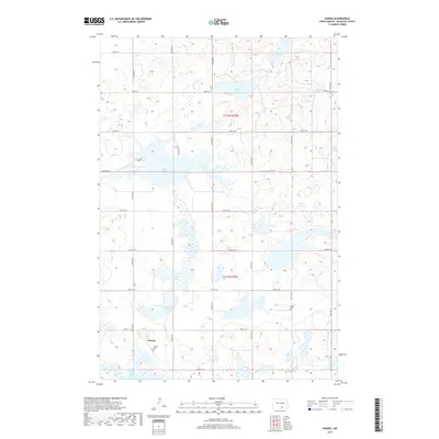
2017 Map of Danzig
USGS Topo · Published 2017About this map
The small settlement of Danzig anchors this survey of south-central North Dakota, where the landscape is defined by the prairie pothole region's distinctive hydrology. This map provides a clear look at the scattered wetlands and glacial depressions that dot the terrain, most notably Green Lake, Clear Lake, and Mud Lake. These water bodies are interspersed among a precise grid of section lines and gravel roads, including 43rd Ave SE and 84th St SE, which have dictated the area's agricultural development for over a century. For those researching local history or genealogy, the map identifies specific sacred sites such as the Danzig Cem just south of the main townsite and the Salem Cem further east. These small cemeteries, along with the remaining structures of Danzig, represent the enduring legacy of the German-Russian immigrant communities that originally settled McIntosh County.
Find a feature on this map
26 named features on this map. Tap any name to fly to it.
Don’t see what you’re looking for? This feature index may not catch every label — zoom into the map to look around manually.
Map Details
Editions of this 2017 Danzig Map
This is the sole edition of this map. No revisions or reprints were ever made.
Other maps of this area

1953 · Jamestown
USGS Topo · 1:250,000

1956 · Jamestown
USGS Topo · 1:250,000

1982 · Danzig
USGS Topo · 1:24,000

1982 · Ashley East
USGS Topo · 1:24,000

1982 · May Lake
USGS Topo · 1:24,000
1982 · May Lake SE
USGS Topo · 1:24,000

1982 · Ashley NE
USGS Topo · 1:24,000

1982 · Lehr SW
USGS Topo · 1:24,000
1982 · Ashley West
USGS Topo · 1:24,000

1982 · Wishek
USGS Topo · 1:24,000