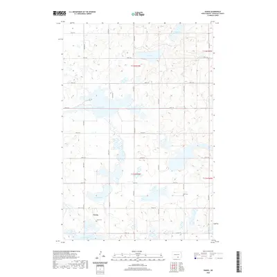
2020 Map of Danzig
USGS Topo · Published 2020About this map
Danzig anchors the southern portion of this McIntosh County landscape, situated amid a terrain defined by numerous prairie potholes and seasonal wetlands. The settlement is flanked by local burial grounds, including the Danzig Cem to its south and Salem Cem to the northeast, providing essential points of reference for genealogists and local historians. The surrounding countryside is heavily marked by water bodies of varying sizes, from the larger Green Lake and Clear Lake in the northern sections to Pudwill Lake and Goose Lake further south. A grid of section roads, such as 84th St SE and 87th St SE, provides access through the township boundaries of T131N and T132N. This modern survey illustrates the persistent rural character of the region, where the natural hydrology of the Missouri Coteau continues to shape the placement of roads and homesteads.
Find a feature on this map
22 named features on this map. Tap any name to fly to it.
Don’t see what you’re looking for? This feature index may not catch every label — zoom into the map to look around manually.
Map Details
Editions of this 2020 Danzig Map
This is the sole edition of this map. No revisions or reprints were ever made.
Other maps of this area

1953 · Jamestown
USGS Topo · 1:250,000

1956 · Jamestown
USGS Topo · 1:250,000

1982 · Danzig
USGS Topo · 1:24,000

1982 · Ashley East
USGS Topo · 1:24,000

1982 · May Lake
USGS Topo · 1:24,000
1982 · May Lake SE
USGS Topo · 1:24,000

1982 · Ashley NE
USGS Topo · 1:24,000

1982 · Lehr SW
USGS Topo · 1:24,000
1982 · Ashley West
USGS Topo · 1:24,000

1982 · Wishek
USGS Topo · 1:24,000