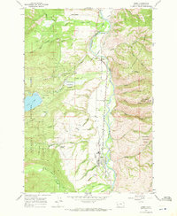
1964 Map of Darby
USGS Topo · Published 1971About this map
The Bitterroot River valley anchors this mid-century portrait of Ravalli County, where the Northern Pacific railroad tracks and US Route 93 run parallel through the heart of Darby. The landscape reflects a sophisticated water management system necessary for the region's agricultural life, featuring the Bitterroot Irrigation District Supply Canal and the notable Bitterroot Irrigation District Siphon. To the west, the Bitterroot National Forest rises sharply, containing Lake Como and several family-named landmarks like Williams Gulch and Overturf Gulch. Small settlements such as Charlas Heights and University Heights reveal the residential footprint of the era. Genealogists will find the Lone Pine Cem north of town, while the presence of a Gravel Pit near Gorus points to the local infrastructure and industry of the 1960s.
Find a feature on this map
49 named features on this map. Tap any name to fly to it.
Don’t see what you’re looking for? This feature index may not catch every label — zoom into the map to look around manually.
Map Details
Editions of this 1964 Darby Map
3 editions found
Other maps of this area

1901 · Hamilton
USGS Topo · 1:125,000

1956 · Elk City
USGS Topo · 1:250,000

1956 · Hamilton
USGS Topo · 1:250,000

1959 · Hamilton
USGS Topo · 1:250,000

1960 · Elk City
USGS Topo · 1:250,000

1960 · Hamilton
USGS Topo · 1:250,000

1964 · Hamilton
USGS Topo · 1:250,000

1964 · Hamilton South
USGS Topo · 1:24,000

1964 · Burnt Ridge
USGS Topo · 1:24,000

1964 · Darby
USGS Topo · 1:24,000