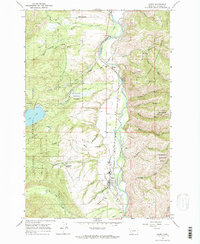
1964 Map of Darby
USGS Topo · Published 1971About this map
Bitterroot River water management and early transportation define this mid-1960s study of Ravalli County. The Northern Pacific Railroad runs parallel to the river, threading through the settlements of Darby and Como. This corridor is heavily engineered with irrigation infrastructure, including the Hedge Ditch, the Bitterroot Irrigation District Supply Canal, and the Bitterroot Irrigation District Siphon Canal, reflecting the valley's reliance on managed water for agriculture and development.
Find a feature on this map
49 named features on this map. Tap any name to fly to it.
Don’t see what you’re looking for? This feature index may not catch every label — zoom into the map to look around manually.
Map Details
Editions of this 1964 Darby Map
3 editions found
Other maps of this area

1901 · Hamilton
USGS Topo · 1:125,000

1956 · Elk City
USGS Topo · 1:250,000

1956 · Hamilton
USGS Topo · 1:250,000

1959 · Hamilton
USGS Topo · 1:250,000

1960 · Elk City
USGS Topo · 1:250,000

1960 · Hamilton
USGS Topo · 1:250,000

1964 · Hamilton
USGS Topo · 1:250,000

1964 · Hamilton South
USGS Topo · 1:24,000

1964 · Burnt Ridge
USGS Topo · 1:24,000

1964 · Darby
USGS Topo · 1:24,000