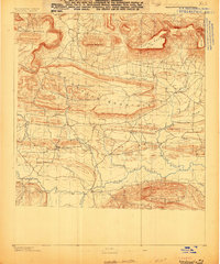
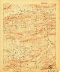
1888 Map of Dardanelle #3
USGS Topo · Published 1888About this map
Danville and Belleville stand as the primary centers of settlement in this late 19th-century survey of Yell County. The landscape is defined by the heavy ridgelines of the Ouachita foothills, most notably the massive Chickalah Mountain which bisects the northern half of the sheet. At this time, the area was a network of small post offices and rural crossroads like Hobert P.O., Milan, and Ranger, connected by early road systems that followed the valleys of Chickalah Creek and the Petit river.
Find a feature on this map
30 named features on this map. Tap any name to fly to it.
Don’t see what you’re looking for? This feature index may not catch every label — zoom into the map to look around manually.
Map Details
Editions of this 1888 Dardanelle #3 Map
This is the sole edition of this map. No revisions or reprints were ever made.
Other maps of this area
1879 · Mountain Home
USGS Topo · 1:62,500
1887 · Magazine Mountain #1
USGS Topo · 1:62,500
1887 · Magazine Mountain #4
USGS Topo · 1:62,500

1887 · Magazine Mountain
USGS Topo · 1:62,500
1888 · Dardanelle #4
USGS Topo · 1:62,500
1888 · Dardanelle #2
USGS Topo · 1:62,500
1888 · Dardanelle #1
USGS Topo · 1:62,500

1890 · Magazine Mountain
USGS Topo · 1:125,000
1890 · Mount Ida
USGS Topo · 1:125,000
1890 · Hot Springs
USGS Topo · 1:125,000