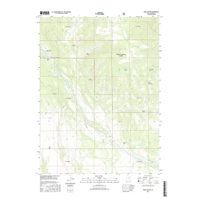
2017 Map of Dark Canyon
USGS Topo · Published 2017About this map
Ashley National Forest dominates the upper half of this Duchesne County landscape, where deep drainages like Dark Canyon and Harmston Canyon cut through the high plateau. The map details a sophisticated water management network vital to this arid region, featuring the Uintah Canal and Cedarview Canal along with the Ant Reservoirs. Transportation through the canyon country is marked by essential crossings such as the Upper Uinta Canal Bridge and Lower Uinta Canal Bridge. Named local landmarks such as John Starr Flat and Henry Olsen Draw provide specific points of reference for genealogical research or historical land use studies. The terrain is further defined by a high density of water sources including Grits Spring, Mugwimp Spring, and Puppy Spring, illustrating the importance of every reliable seep and flow in the Uinta River watershed during the early 21st century.
Find a feature on this map
57 named features on this map. Tap any name to fly to it.
Don’t see what you’re looking for? This feature index may not catch every label — zoom into the map to look around manually.
Map Details
Editions of this 2017 Dark Canyon Map
This is the sole edition of this map. No revisions or reprints were ever made.
Other maps of this area

1885 · Ashley
USGS Topo · 1:250,000

1885 · Uinta
USGS Topo · 1:250,000

1905 · Gilbert Peak
USGS Topo · 1:125,000

1906 · Gilbert Peak
USGS Topo · 1:125,000

1906 · Marsh Peak
USGS Topo · 1:125,000

1908 · Marsh Peak
USGS Topo · 1:125,000

1917 · Vernal
USGS Topo · 1:125,000

1939 · Duchesne
USGS Topo · 1:125,000

1954 · Salt Lake City
USGS Topo · 1:250,000

1954 · Vernal
USGS Topo · 1:250,000