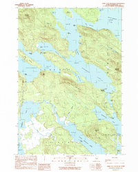
1990 Map of Dark Cove Mountain
USGS Topo · Published 1990About this map
Dark Cove Mountain rises as a central landmark amidst an intricate system of interconnected waterways in this remote section of Washington County. The 1990 landscape is dominated by large glacial lakes including Sysladobsis Lake, Pocumcus Lake, and Wabassus Lake, linked by narrow passages like the Pocumcus Narrows and the Thoroughfare. Human activity is centered on the water, with Dobsis Dam and the Dennison Portage marking historical transit points for timber or travel between the lake systems. Small settlements and seasonal locations like The Birches and Elsemore Landing are situated along the shores, while the presence of Sand and Gravel Pits suggests localized resource extraction. The area's geography is further defined by various named coves and points, such as Steamboat Cove and Belmont Point, which served as essential navigational markers for those traversing the lakes by boat.
Find a feature on this map
49 named features on this map. Tap any name to fly to it.
Don’t see what you’re looking for? This feature index may not catch every label — zoom into the map to look around manually.
Map Details
Editions of this 1990 Dark Cove Mountain Map
This is the sole edition of this map. No revisions or reprints were ever made.
Other maps of this area

1931 · Springfield
USGS Topo · 1:48,000

1932 · Nicatous Lake
USGS Topo · 1:48,000

1934 · Nicatous Lake
USGS Topo · 1:62,500

1934 · Springfield
USGS Topo · 1:62,500

1941 · Scraggly Lake
USGS Topo · 1:62,500

1941 · Wabassus Lake
USGS Topo · 1:62,500

1943 · Wabassus Lake
USGS Topo · 1:62,500

1944 · Scraggly Lake
USGS Topo · 1:62,500

1953 · Wabassus Lake
USGS Topo · 1:62,500

1954 · Millinocket
USGS Topo · 1:250,000