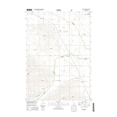
2013 Map of Darlington
USGS Topo · Published 2013About this map
Big Lost River bisects the valley floor, defining the agricultural character of this central Idaho landscape. The small settlements of Leslie and Darlington serve as the primary human hubs, situated along a network of ranching roads like Leslie Rd and Fullmer Rd. This area reveals a sophisticated water management system critical to high-desert farming, featuring an extensive grid of irrigation infrastructure including the Blaine Canal, Three in One Ditch, and Angelo Ditch. To the west, the terrain rises sharply into the White Knob Mountains and Sheep Canyon, while the eastern portion provides access to the Challis National Forest. Local history is anchored at the Darlington Cem, while unusual geological features like the Darlington Sinks highlight the unique hydrology of the Big Lost River Valley.
Find a feature on this map
41 named features on this map. Tap any name to fly to it.
Don’t see what you’re looking for? This feature index may not catch every label — zoom into the map to look around manually.
Map Details
Editions of this 2013 Darlington Map
This is the sole edition of this map. No revisions or reprints were ever made.
Other maps of this area

1935 · MacKay
USGS Topo · 1:96,000

1940 · Mackay
USGS Topo · 1:62,500

1955 · Idaho Falls
USGS Topo · 1:250,000

1958 · Idaho Falls
USGS Topo · 1:250,000

1960 · Grouse
USGS Topo · 1:62,500

1960 · Mackay
USGS Topo · 1:62,500

1969 · Darlington
USGS Topo · 1:24,000

1969 · Ramshorn Canyon
USGS Topo · 1:24,000

1969 · Sunset Peak
USGS Topo · 1:24,000
1969 · Methodist Creek
USGS Topo · 1:24,000