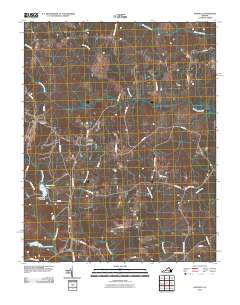
2010 Map of Darvills
USGS Topo · Published 2010About this map
Darvills sits at the center of this rural Dinwiddie County landscape, characterized by a dense network of country roads and small creek branches. The 2010 geography reveals a place where local heritage is preserved in the Sharon Cemetery and Butterwood Cemetery, both of which are central to the community's local history. A notable portion of the western boundary is defined by the edge of Fort Pickett, a significant regional military installation. Hydrological features dominate the southern half of the quadrangle, where Tommeheton Lake is held by the Tommeheton Lake Dam. The terrain is finely drained by a series of waterways, including Butterwood Creek, Turkey Egg Creek, and White Oak Creek, illustrating the traditional agricultural and timber-based drainage patterns of this part of southern Virginia.
Find a feature on this map
42 named features on this map. Tap any name to fly to it.
Don’t see what you’re looking for? This feature index may not catch every label — zoom into the map to look around manually.
Map Details
Editions of this 2010 Darvills Map
This is the sole edition of this map. No revisions or reprints were ever made.
Other maps of this area

1897 · Amelia
USGS Topo · 1:125,000

1918 · Lawrenceville
USGS Topo · 1:62,500

1919 · Mc Kenney
USGS Topo · 1:48,000

1920 · Lawrenceville
USGS Topo · 1:48,000

1921 · Mc Kenney
USGS Topo · 1:62,500

1921 · Lawrenceville
USGS Topo · 1:62,500

1942 · Lawrenceville
USGS Topo · 1:62,500

1943 · Mc Kenney
USGS Topo · 1:62,500

1943 · De Witt
USGS Topo · 1:24,000

1943 · Church Road
USGS Topo · 1:24,000