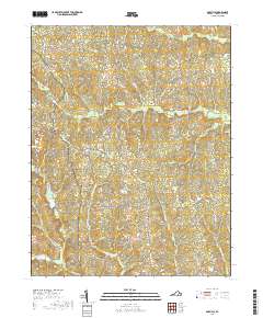
2019 Map of Darvills
USGS Topo · Published 2019About this map
Darvills serves as the central hub for this rural portion of Dinwiddie County, where a network of family-named roads and country cemeteries defines the landscape. The settlement is anchored by the presence of Sharon Cem nearby, while other historic burials such as Butterwood Cem and Booth Cem are scattered across the surrounding woods and fields. This area is characterized by an intricate drainage system, with numerous tributaries including Butterwood Creek and Beaver Pond Cr carving through the terrain. The road network, featuring names like Gills Bridge Rd and White Oak Church Rd, suggests a long history of local travel between small farmsteads and rural parishes. The land remains largely undeveloped, preserving the traditional drainage patterns of Turkey Egg Cr and Birchin Creek as they meander through the southern reaches of the quadrangle.
Find a feature on this map
52 named features on this map. Tap any name to fly to it.
Don’t see what you’re looking for? This feature index may not catch every label — zoom into the map to look around manually.
Map Details
Editions of this 2019 Darvills Map
This is the sole edition of this map. No revisions or reprints were ever made.
Other maps of this area

1897 · Amelia
USGS Topo · 1:125,000

1918 · Lawrenceville
USGS Topo · 1:62,500

1919 · Mc Kenney
USGS Topo · 1:48,000

1920 · Lawrenceville
USGS Topo · 1:48,000

1921 · Mc Kenney
USGS Topo · 1:62,500

1921 · Lawrenceville
USGS Topo · 1:62,500

1942 · Lawrenceville
USGS Topo · 1:62,500

1943 · Mc Kenney
USGS Topo · 1:62,500

1943 · De Witt
USGS Topo · 1:24,000

1943 · Church Road
USGS Topo · 1:24,000