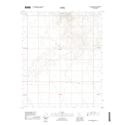
2018 Map of Date Creek Ranch NW
USGS Topo · Published 2018About this map
Tres Alamos Spring and the rugged drainage of Date Creek define this arid landscape in Yavapai County. The topography is marked by significant elevation changes, with the high points of Tres Alamos overlooking a network of dry washes and seasonal water catchments like Myers Tank and North Tank. These water sources were essential for ranching and travel in this high desert environment. Evidence of regional transit is seen in the path of Alamo Rd and Pipeline Ranch Rd, which navigate the contours of the land south toward Bullard Wash. This 2018 survey provides a clear view of the sparse infrastructure and natural features that have dictated movement and survival in this corner of the Arizona desert.
Find a feature on this map
18 named features on this map. Tap any name to fly to it.
Don’t see what you’re looking for? This feature index may not catch every label — zoom into the map to look around manually.
Map Details
Editions of this 2018 Date Creek Ranch NW Map
This is the sole edition of this map. No revisions or reprints were ever made.
Other maps of this area

1923 · Signal
USGS Topo · 1:250,000

1942 · Signal
USGS Topo · 1:250,000

1950 · Prescott
USGS Topo · 1:250,000

1954 · Prescott
USGS Topo · 1:250,000

1958 · Prescott
USGS Topo · 1:250,000

1959 · Prescott
USGS Topo · 1:250,000

1960 · Prescott
USGS Topo · 1:250,000

1965 · Prescott
USGS Topo · 1:250,000
1967 · Smith Peak
USGS Topo · 1:24,000
1967 · Date Creek Ranch NW
USGS Topo · 1:24,000