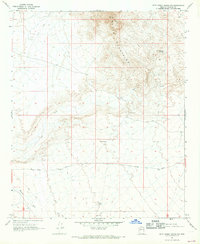
1967 Map of Date Creek Ranch NW
USGS Topo · Published 1969About this map
Black Mountains dominate the upper portion of this topographic survey, marking a stark transition between high-desert elevations and the alluvial plains below. This high-desert environment in the late 1960s is defined by its water management for livestock or local transit, indicated by the presence of Myers Tank, North Tank, and a lone Water Tank. Along the lower slopes of the range, a Prospect suggests localized mineral exploration, while Tres Alamos Spring provides a rare natural water source near the base of the Tres Alamos feature.
Find a feature on this map
23 named features on this map. Tap any name to fly to it.
Don’t see what you’re looking for? This feature index may not catch every label — zoom into the map to look around manually.
Map Details
Editions of this 1967 Date Creek Ranch NW Map
2 editions found
Other maps of this area

1923 · Signal
USGS Topo · 1:250,000

1942 · Signal
USGS Topo · 1:250,000

1950 · Prescott
USGS Topo · 1:250,000

1954 · Prescott
USGS Topo · 1:250,000

1958 · Prescott
USGS Topo · 1:250,000

1959 · Prescott
USGS Topo · 1:250,000

1960 · Prescott
USGS Topo · 1:250,000

1965 · Prescott
USGS Topo · 1:250,000
1967 · Smith Peak
USGS Topo · 1:24,000
1967 · Arrastra Mtn SE
USGS Topo · 1:24,000