
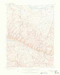
1916 Map of Daton Peak
USGS Topo · Published 1958About this map
The Yampa River valley and the high Williams Fork Mountains dominate this 1916 landscape during a period of active coal mining and early ranching development. The northern edge of the map follows the Denver and Salt Lake railroad line through Hayden, where the Cary Ranch and associated Cary Mines mark the local industrial footprint. To the south, the terrain rises sharply toward Daton Peak and the timbered reaches of the Routt National Forest. Isolated community life is visible in the network of rural schoolhouses and small outposts, such as the Pagoda School, Dunstan School, and the Willow Creek Store. These small landmarks, along with family-named operations like Jim Gunns Mine and Kelly Lodge, illustrate the dispersed settlement pattern typical of the Yampa Valley's mountainous interior before modern infrastructure arrived.
Find a feature on this map
55 named features on this map. Tap any name to fly to it.
Don’t see what you’re looking for? This feature index may not catch every label — zoom into the map to look around manually.
Map Details
Editions of this 1916 Daton Peak Map
2 editions found
Other maps of this area

1910 · Danforth Hills
USGS Topo · 1:125,000

1915 · Monument Butte
USGS Topo · 1:62,500

1916 · Craig
USGS Topo · 1:125,000

1920 · Daton Peak
USGS Topo · 1:62,500

1923 · Elkhead Creek
USGS Topo · 1:62,500

1923 · Pilot Knob
USGS Topo · 1:62,500

1924 · Elkhead Creek
USGS Topo · 1:62,500

1924 · Mt. Harris
USGS Topo · 1:48,000

1925 · Pilot Knob
USGS Topo · 1:62,500

1926 · Mount Harris
USGS Topo · 1:62,500