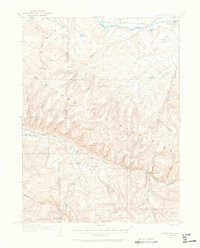
1916 Map of Daton Peak
USGS Topo · Published 1965About this map
The Williams Fork Mountains dominate this 1916 survey of northwestern Colorado, where the terrain is deeply etched by a network of drainage gulches. Industrial activity is evident along the northern edge with the Denver and Salt Lake railroad following the course of the Yampa River through Hayden. Early 20th-century resource extraction is documented by the presence of the Cary Mine, Jim Dunns Mine, and Cedar Creek Mine, scattered across the high country. Small rural outposts and family-held locations like Cary Ranch, Kelly Lodge, and the Willow Creek Store provide key markers for genealogists. Educational life in these remote drainages is represented by the Pagoda School and Dunstan School, while the border between Moffat and Routt Counties cuts through the western slopes of Breeze Mtn.
Find a feature on this map
51 named features on this map. Tap any name to fly to it.
Don’t see what you’re looking for? This feature index may not catch every label — zoom into the map to look around manually.
Map Details
Editions of this 1916 Daton Peak Map
2 editions found
Other maps of this area

1910 · Danforth Hills
USGS Topo · 1:125,000

1915 · Monument Butte
USGS Topo · 1:62,500

1916 · Craig
USGS Topo · 1:125,000

1916 · Daton Peak
USGS Topo · 1:62,500

1920 · Daton Peak
USGS Topo · 1:62,500

1923 · Elkhead Creek
USGS Topo · 1:62,500

1923 · Pilot Knob
USGS Topo · 1:62,500

1924 · Elkhead Creek
USGS Topo · 1:62,500

1924 · Mt. Harris
USGS Topo · 1:48,000

1925 · Pilot Knob
USGS Topo · 1:62,500