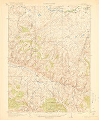
1920 Map of Daton Peak
USGS Topo · Published 1920About this map
The Yampa River valley defines the northern edge of this Northwestern Colorado landscape, where the settlement of Hayden serves as a vital anchor just after the First World War. Moving south, the terrain rises sharply into the Williams Fork Mountains, a region characterized by a network of gulches and small-scale resource extraction. Named operations such as the Cary Mine and Jim Dunns Mine suggest a localized coal or mineral economy active during this era.
Find a feature on this map
55 named features on this map. Tap any name to fly to it.
Don’t see what you’re looking for? This feature index may not catch every label — zoom into the map to look around manually.
Map Details
Editions of this 1920 Daton Peak Map
2 editions found
Other maps of this area

1910 · Danforth Hills
USGS Topo · 1:125,000

1915 · Monument Butte
USGS Topo · 1:62,500

1916 · Craig
USGS Topo · 1:125,000

1916 · Daton Peak
USGS Topo · 1:62,500

1920 · Daton Peak
USGS Topo · 1:62,500

1923 · Elkhead Creek
USGS Topo · 1:62,500

1923 · Pilot Knob
USGS Topo · 1:62,500

1924 · Elkhead Creek
USGS Topo · 1:62,500

1924 · Mt. Harris
USGS Topo · 1:48,000

1925 · Pilot Knob
USGS Topo · 1:62,500