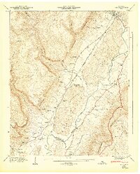
1947 Map of Daus
USGS Topo · Published 1947About this map
The Sequatchie Valley dominates this 1946 field examination, showcasing a landscape defined by the dramatic wall of the Cumberland Escarpment and the meanders of the Sequatchie River. This era of development is marked by the industrial presence of the Nashville Chattanooga and St Louis Railroad, which parallels the Alvin York Highway through the valley floor. Small farming communities and family landmarks such as Daus, Liberty, and Dunlap Cem illustrate the settlement patterns of the mid-twentieth century.
Find a feature on this map
59 named features on this map. Tap any name to fly to it.
Don’t see what you’re looking for? This feature index may not catch every label — zoom into the map to look around manually.
Map Details
Editions of this 1947 Daus Map
This is the sole edition of this map. No revisions or reprints were ever made.
Other maps of this area

1888 · Chattanooga
USGS Topo · 1:125,000

1893 · Chattanooga
USGS Topo · 1:125,000

1895 · Sewanee
USGS Topo · 1:125,000

1935 · Mount Airy
USGS Topo · 1:24,000

1936 · Palmer
USGS Topo · 1:24,000

1936 · Daus
USGS Topo · 1:24,000

1936 · Henson Gap
USGS Topo · 1:24,000

1936 · Whitwell
USGS Topo · 1:24,000

1936 · Ketner Gap
USGS Topo · 1:24,000

1936 · Fairmount
USGS Topo · 1:24,000