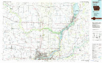
1984 Map of Davenport
USGS Topo · Published 1985About this map
The Mississippi River and the meandering Wapsipinicon River dominate this mid-1980s landscape, illustrating the dense river-and-rail infrastructure of the Quad Cities area. Industrial and urban expansion is evident in Davenport, Bettendorf, and Moline, while the surrounding rural counties preserve smaller 19th-century settlements like Oxford Mills and Massillon. Transportation corridors such as the Chicago Rock Island and Pacific railroad and I-80 trace the region's development as a shipping hub.
Find a feature on this map
161 named features on this map. Tap any name to fly to it.
Don’t see what you’re looking for? This feature index may not catch every label — zoom into the map to look around manually.
Map Details
Editions of this 1984 Davenport Map
2 editions found
Other maps of this area

1889 · Tipton
USGS Topo · 1:62,500

1890 · Durant
USGS Topo · 1:62,500

1890 · Tipton
USGS Topo · 1:62,500

1891 · DeWitt
USGS Topo · 1:62,500

1891 · Davenport
USGS Topo · 1:62,500

1891 · Monticello
USGS Topo · 1:62,500

1891 · Maquoketa
USGS Topo · 1:62,500

1891 · Wilton Junction
USGS Topo · 1:62,500

1891 · Baldwin
USGS Topo · 1:62,500

1891 · Clinton
USGS Topo · 1:62,500