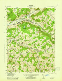
1945 Map of Davenport
USGS Topo · Published 1945About this map
Charlotte Creek and its broad valley anchor the northern half of this Delaware County survey, where the settlements of Davenport and Fergusonville are situated. The landscape transitions into the rolling uplands of South Hill and Harpersfield Hill, deeply etched by drainage routes like Middle Brook and Wright Brook. In the southern portion, the watershed of Kortright Creek defines the local geography, supporting dairy-era infrastructure such as Creamery Pond near the village of Kortright Station.
Find a feature on this map
48 named features on this map. Tap any name to fly to it.
Don’t see what you’re looking for? This feature index may not catch every label — zoom into the map to look around manually.
Map Details
Editions of this 1945 Davenport Map
This is the sole edition of this map. No revisions or reprints were ever made.
Other maps of this area

1904 · Richmondville
USGS Topo · 1:62,500

1904 · Hobart
USGS Topo · 1:62,500

1907 · Cooperstown
USGS Topo · 1:62,500

1909 · Cooperstown
USGS Topo · 1:62,500

1909 · Delhi
USGS Topo · 1:62,500

1911 · Delhi
USGS Topo · 1:62,500

1943 · Delhi
USGS Topo · 1:24,000

1943 · Milford
USGS Topo · 1:24,000

1943 · Bloomville
USGS Topo · 1:24,000

1943 · Charlotteville
USGS Topo · 1:24,000