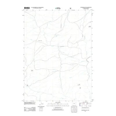
2012 Map of Davidson Flats
USGS Topo · Published 2012About this map
Davidson Flats sits at the heart of this high-plains landscape in Albany County, where complex drainage networks define the topography. The terrain is marked by significant features like Pine Mountain and the distinctively named Split Rock to the southeast, while the northern reaches are dominated by Britania Mountain. The water system is particularly intricate, featuring the Sturgeon-Number 1 Reservoir and numerous seasonal and perennial flows including Siebolt Cr, McFarlane Cr, and Duck Cr. Near the southern boundary, the topography drops toward Duck Creek Falls, a notable point of interest where the local hydrology transitions. This modern survey reflects the enduring character of Wyoming's ranching and wilderness lands, showing the established path of Cottonwood Park Rd and the remote Red Rock Trl as they navigate between draws and mountain flanks.
Find a feature on this map
24 named features on this map. Tap any name to fly to it.
Don’t see what you’re looking for? This feature index may not catch every label — zoom into the map to look around manually.
Map Details
Editions of this 2012 Davidson Flats Map
This is the sole edition of this map. No revisions or reprints were ever made.
Other maps of this area

1954 · Torrington
USGS Topo · 1:250,000

1954 · Cheyenne
USGS Topo · 1:250,000

1955 · Dodge Ranch
USGS Topo · 1:24,000

1955 · Moonshine Peak
USGS Topo · 1:24,000

1955 · Bull Camp Peak
USGS Topo · 1:24,000

1958 · Cheyenne
USGS Topo · 1:250,000

1958 · Torrington
USGS Topo · 1:250,000

1968 · Cow Creek Mountain
USGS Topo · 1:24,000

1968 · Davidson Flats
USGS Topo · 1:24,000
1968 · Reese Mountain
USGS Topo · 1:24,000