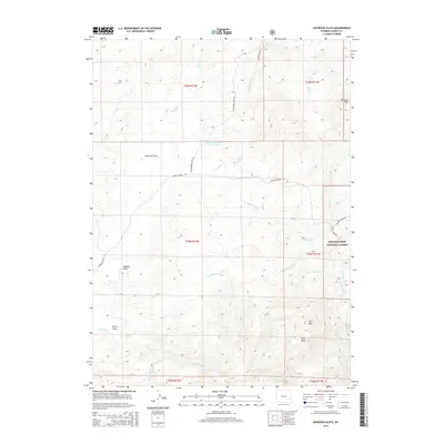
2015 Map of Davidson Flats
USGS Topo · Published 2015About this map
Davidson Flats sits at the heart of this high-elevation landscape in Albany County, where the plains give way to the rising slopes of the Medicine Bow National Forest. The geography is defined by a dense network of drainages and seasonal watercourses, including Siebolt Cr, McFarlane Cr, and Duck Cr, which have carved out distinctive features like Wallace Draw and Mertz Draw. This 2015 survey illustrates the modern configuration of rural infrastructure, from the Sturgeon Number 1 Reservoir to a system of mountain roads like Palmer Canyon Rd and Wheeler Flats Rd. The eastern portion of the quadrangle rises significantly toward landmarks such as Britania Mtn, Pine Mtn, and the unique formation at Split Rock, marking the transition into the forested wilderness of the national forest system.
Find a feature on this map
29 named features on this map. Tap any name to fly to it.
Don’t see what you’re looking for? This feature index may not catch every label — zoom into the map to look around manually.
Map Details
Editions of this 2015 Davidson Flats Map
This is the sole edition of this map. No revisions or reprints were ever made.
Other maps of this area

1954 · Torrington
USGS Topo · 1:250,000

1954 · Cheyenne
USGS Topo · 1:250,000

1955 · Dodge Ranch
USGS Topo · 1:24,000

1955 · Moonshine Peak
USGS Topo · 1:24,000

1955 · Bull Camp Peak
USGS Topo · 1:24,000

1958 · Cheyenne
USGS Topo · 1:250,000

1958 · Torrington
USGS Topo · 1:250,000

1968 · Cow Creek Mountain
USGS Topo · 1:24,000

1968 · Davidson Flats
USGS Topo · 1:24,000
1968 · Reese Mountain
USGS Topo · 1:24,000