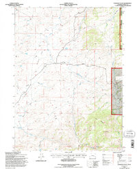
1992 Map of Davidson Flats
USGS Topo · Published 1996About this map
Davidson Flats and the surrounding high country of Albany County appear here in a transition period for federal land management, based on 1967 aerial photography with revisions through the early 1990s. The map illustrates a landscape of high plains and rugged rises where the eastern edge of the Medicine Bow National Forest meets private ranch lands. Water sources are critical in this environment, as evidenced by the dense network of drainage including Mertz Creek, Siebolt Creek, and the notable Duck Creek Falls in the south. Human activity is marked by the presence of a Landing Strip and a modern Pipeline cutting across the northern reaches near Britannia Mountain. To the south, Pine Mountain and the distinctively named Split Rock serve as significant topographic anchors for the region, while Palmer Canyon Road provides the primary east-west transit through this isolated territory.
Find a feature on this map
22 named features on this map. Tap any name to fly to it.
Don’t see what you’re looking for? This feature index may not catch every label — zoom into the map to look around manually.
Map Details
Editions of this 1992 Davidson Flats Map
This is the sole edition of this map. No revisions or reprints were ever made.
Other maps of this area

1954 · Torrington
USGS Topo · 1:250,000

1954 · Cheyenne
USGS Topo · 1:250,000

1955 · Dodge Ranch
USGS Topo · 1:24,000

1955 · Moonshine Peak
USGS Topo · 1:24,000

1955 · Bull Camp Peak
USGS Topo · 1:24,000

1958 · Cheyenne
USGS Topo · 1:250,000

1958 · Torrington
USGS Topo · 1:250,000

1968 · Cow Creek Mountain
USGS Topo · 1:24,000

1968 · Davidson Flats
USGS Topo · 1:24,000
1968 · Reese Mountain
USGS Topo · 1:24,000