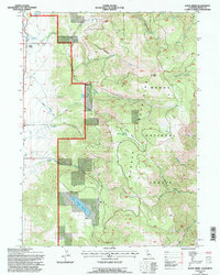
1993 Map of Davis Creek
USGS Topo · Published 1997About this map
Warner Mountains rise sharply in this northeastern corner of California, where the rugged peaks and drainage basins of the Modoc National Forest overlook a series of historic valley settlements. Small communities like Davis Creek, Linnville, and Franklin line the western foothills, connected by a network of unimproved roads and four-wheel-drive trails. The landscape is defined by its complex hydrology, with the North Fork, Middle Fork, and South Fork converging near the valley floor. High-altitude landmarks such as Buck Mountain and Little Baldy dominate the eastern topography, while resource management is evident in features like the Halls Meadows Reservoir and the Aqueduct system that skirts the foothills. This map documents a sparsely populated but active ranching and forest landscape, recording numerous isolated water sources like Needle Grass Spring and Benton Meadow Spring that were vital for local survival and industry.
Find a feature on this map
35 named features on this map. Tap any name to fly to it.
Don’t see what you’re looking for? This feature index may not catch every label — zoom into the map to look around manually.
Map Details
Editions of this 1993 Davis Creek Map
This is the sole edition of this map. No revisions or reprints were ever made.
Other maps of this area

1886 · Alturas
USGS Topo · 1:250,000

1892 · Alturas
USGS Topo · 1:250,000

1954 · Alturas
USGS Topo · 1:250,000

1958 · Alturas
USGS Topo · 1:250,000

1962 · Alturas
USGS Topo · 1:250,000

1962 · Davis Creek
USGS Topo · 1:62,500

1962 · Willow Ranch
USGS Topo · 1:62,500

1962 · Cedarville
USGS Topo · 1:62,500

1962 · Fort Bidwell
USGS Topo · 1:62,500

1965 · Alturas
USGS Topo · 1:250,000