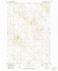
1979 Map of Davis Creek West
USGS Topo · Published 1984About this map
The boundary between Powder River Co and Carter Co bisects this late-twentieth-century landscape, characterized by an intricate network of intermittent watercourses and high ground. Pine Hill and the area marked Timber rise above the drainage systems of Stump Creek and Dry Creek, illustrating the natural relief of this part of southeastern Montana. The presence of a Drill Hole and several instances of Spring indicate the ongoing human efforts to locate and manage water and geological resources in this arid terrain. This 1970s-era topographic study also tracks smaller tributaries like Honeycomb Creek and Flag Creek, providing a detailed look at the hydrology and land partitions of the region before further modern development.
Find a feature on this map
12 named features on this map. Tap any name to fly to it.
Don’t see what you’re looking for? This feature index may not catch every label — zoom into the map to look around manually.
Map Details
Editions of this 1979 Davis Creek West Map
This is the sole edition of this map. No revisions or reprints were ever made.
Other maps of this area

1954 · Ekalaka
USGS Topo · 1:250,000

1956 · Ekalaka
USGS Topo · 1:250,000

1958 · Ekalaka
USGS Topo · 1:250,000

1965 · Ekalaka
USGS Topo · 1:250,000

1979 · W L Butte
USGS Topo · 1:24,000

1979 · Blacktail Creek SE
USGS Topo · 1:24,000

1979 · Blacktail Creek SW
USGS Topo · 1:24,000

1979 · Powderville
USGS Topo · 1:24,000

1979 · Rattlesnake Ridge
USGS Topo · 1:24,000

1979 · McKenzie Creek
USGS Topo · 1:24,000