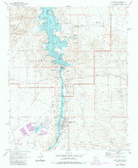
1970 Map of Davis Dam
USGS Topo · Published 1983About this map
Lake Mohave and the Colorado River serve as the central corridor for this 1970s-era topographic study, marking the rugged boundary between Nevada and Arizona. The landscape is defined by the massive infrastructure of Davis Dam and the industrial presence of the Mohave Generating Station, which includes a complex network of slurry ponds and an industrial waste pond. On the Arizona side, Bullhead City and its airport show early development, while the Nevada side features the growing settlement of Laughlin.
Find a feature on this map
41 named features on this map. Tap any name to fly to it.
Don’t see what you’re looking for? This feature index may not catch every label — zoom into the map to look around manually.
Map Details
Editions of this 1970 Davis Dam Map
3 editions found
Other maps of this area

1886 · Camp Mohave
USGS Topo · 1:250,000

1892 · Camp Mohave
USGS Topo · 1:250,000

1926 · Mohave City
USGS Topo · 1:96,000

1942 · Camp Mohave
USGS Topo · 1:250,000

1947 · Kingman
USGS Topo · 1:250,000

1948 · Kingman
USGS Topo · 1:250,000

1950 · Davis Dam
USGS Topo · 1:62,500

1952 · Davis Dam
USGS Topo · 1:62,500

1954 · Kingman
USGS Topo · 1:250,000

1955 · Kingman
USGS Topo · 1:250,000