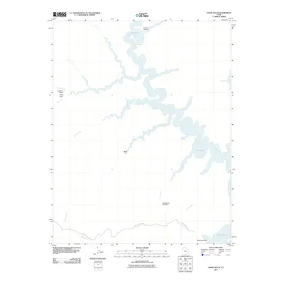
2011 Map of Davis Gulch
USGS Topo · Published 2011About this map
Lake Powell dominates the canyon landscape in this 2011 survey of southern Utah. The map documents the intricate branching of the reservoir into several named canyons and gulches, including Explorer Canyon, Davis Gulch, and Willow Gulch. Along the southern portion of the sheet, the legendary Hole-in-the-Rock Rd winds through the terrain, leading toward the historic crossing point at Hole-in-the-Rock. This area is characterized by the intersection of early pioneer routes and the modern shoreline, where features such as Cathedral in the Desert sit within the drainage of Clear Creek. The map provides a precise record of how the rising waters have reshaped access to these remote desert landmarks, marking the contemporary relationship between the high desert floor and the expanded reaches of the Colorado River system.
Find a feature on this map
13 named features on this map. Tap any name to fly to it.
Don’t see what you’re looking for? This feature index may not catch every label — zoom into the map to look around manually.
Map Details
Editions of this 2011 Davis Gulch Map
This is the sole edition of this map. No revisions or reprints were ever made.
Other maps of this area

1886 · Escalante
USGS Topo · 1:250,000

1886 · Henry Mountains
USGS Topo · 1:250,000

1892 · Henry Mountains
USGS Topo · 1:250,000

1953 · Cummings Mesa
USGS Topo · 1:62,500

1953 · The Rincon
USGS Topo · 1:62,500

1953 · Navajo Mountain
USGS Topo · 1:62,500

1956 · Escalante
USGS Topo · 1:250,000

1960 · Escalante
USGS Topo · 1:250,000
1968 · Sooner Bench
USGS Topo · 1:24,000
1968 · King Mesa
USGS Topo · 1:24,000