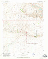
1968 Map of King Mesa
USGS Topo · Published 1971About this map
King Mesa and the surrounding high desert plateaus are defined by deep drainage systems and prominent geological formations in this late 1960s survey of southern Utah. The Escalante River winds through the northeast corner, while the complex erosional patterns of Coyote Gulch and Hurricane Wash dominate the central terrain. This map captures a transitional period for the Glen Canyon National Recreation Area, showing a proposed boundary line that would shape the region's conservation future. Significant natural landmarks are documented throughout, including the Jacob Hamblin Arch, Coyote Natural Bridge, and the towering Chimney Rock. A series of isolated water sources such as Gates Tank and King Spring underscore the arid nature of the Ezra Mc Bench Area, while early access is marked by several unnamed Jeep Trails cutting across Fortymile Ridge.
Find a feature on this map
21 named features on this map. Tap any name to fly to it.
Don’t see what you’re looking for? This feature index may not catch every label — zoom into the map to look around manually.
Map Details
Editions of this 1968 King Mesa Map
3 editions found
Other maps of this area

1886 · Escalante
USGS Topo · 1:250,000

1886 · Henry Mountains
USGS Topo · 1:250,000

1892 · Henry Mountains
USGS Topo · 1:250,000

1953 · Mt Pennell 3 SW
USGS Topo · 1:24,000

1953 · Circle Cliffs 4 SW
USGS Topo · 1:24,000

1953 · The Rincon
USGS Topo · 1:62,500

1953 · Hall Mesa
USGS Topo · 1:62,500

1953 · Moody Creek
USGS Topo · 1:62,500

1956 · Escalante
USGS Topo · 1:250,000

1960 · Escalante
USGS Topo · 1:250,000