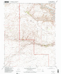
1968 Map of King Mesa
USGS Topo · Published 1995About this map
The Escalante River winds through the northern portion of this Kane County quadrangle, carving deep drainages that define the high desert landscape. In the late 1960s, this area within the Glen Canyon National Recreation Area remained largely inaccessible except via primitive 4wd tracks and footpaths. The map highlights numerous sandstone formations, including the Jacob Hamblin Arch, Coyote Natural Bridge, and the Sunset Natural Arch near Fortymile Ridge. These natural landmarks, along with features like Chimney Rock and King Mesa, served as critical navigational aids for early surveyors and explorers. Water sources like King Spring and Gates Tank are documented, indicating the sparse but vital hydrology of Scorpion Canyon and the surrounding Ezra M C Bench. The map records the intricate network of the Coyote Gulch and Hurricane Wash, showcasing the erosional patterns of the Colorado Plateau.
Find a feature on this map
21 named features on this map. Tap any name to fly to it.
Don’t see what you’re looking for? This feature index may not catch every label — zoom into the map to look around manually.
Map Details
Editions of this 1968 King Mesa Map
3 editions found
Other maps of this area

1886 · Escalante
USGS Topo · 1:250,000

1886 · Henry Mountains
USGS Topo · 1:250,000

1892 · Henry Mountains
USGS Topo · 1:250,000

1953 · Mt Pennell 3 SW
USGS Topo · 1:24,000

1953 · Circle Cliffs 4 SW
USGS Topo · 1:24,000

1953 · The Rincon
USGS Topo · 1:62,500

1953 · Hall Mesa
USGS Topo · 1:62,500

1953 · Moody Creek
USGS Topo · 1:62,500

1956 · Escalante
USGS Topo · 1:250,000

1960 · Escalante
USGS Topo · 1:250,000