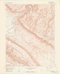
1960 Map of Davis Mesa
USGS Topo · Published 1961About this map
The Dolores River cuts through the northwest corner of this Montrose County landscape, where the dramatic elevation shifts of the Colorado Plateau are on full display. The area is defined by the broad Paradox Valley, flanked by the massive elevations of Davis Mesa and Martin Mesa. This 1960 revision reveals an intensive history of uranium and vanadium mining, with a dense concentration of claims such as the La Salle Mine, CF&I Mine, and Honeymoon Mine clustered along the canyon walls and mesa rims. Beyond the industry, the map documents the sparse but vital water sources in this arid environment, including Salt Water, a Salt Well, and a Salt Evaporator near Paradox Creek. A solitary Grave located south of Coral No 1 provides a poignant genealogical detail amidst the rugged canyons and industrial activity.
Find a feature on this map
51 named features on this map. Tap any name to fly to it.
Don’t see what you’re looking for? This feature index may not catch every label — zoom into the map to look around manually.
Map Details
Editions of this 1960 Davis Mesa Map
2 editions found
Other maps of this area

1916 · Paradox Valley
USGS Topo · 1:125,000

1922 · Paradox Valley
USGS Topo · 1:125,000

1948 · Roc Creek
USGS Topo · 1:24,000

1948 · Bull Canyon
USGS Topo · 1:24,000

1948 · Uravan
USGS Topo · 1:24,000

1948 · Naturita NW
USGS Topo · 1:24,000

1948 · Paradox
USGS Topo · 1:24,000

1949 · Bull Canyon
USGS Topo · 1:24,000

1949 · Davis Mesa
USGS Topo · 1:24,000

1949 · Uravan
USGS Topo · 1:24,000