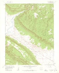
1960 Map of Davis Mesa
USGS Topo · Published 1961About this map
Mining operations dominate the rugged landscape of Montrose County during this mid-century survey, specifically concentrated around the high plateaus and canyon rims. The Dolores River cuts through the northwest, while the Paradox Valley floor shows early industrial and agricultural infrastructure, including a Salt Evaporator and Corral No 1. The map is particularly notable for its dense cluster of named mines on the eastern slopes of Davis Mesa, where claims like the Dorothy Mine, Phonograph Mine, and Florence-Nellie Mine illustrate the region's intensive uranium and vanadium prospecting era. Away from the industrial activity, smaller details such as a lone Grave near Paradox Creek and various dams provide evidence of the scattered human presence in this high-desert terrain.
Find a feature on this map
50 named features on this map. Tap any name to fly to it.
Don’t see what you’re looking for? This feature index may not catch every label — zoom into the map to look around manually.
Map Details
Editions of this 1960 Davis Mesa Map
2 editions found
Other maps of this area

1916 · Paradox Valley
USGS Topo · 1:125,000

1922 · Paradox Valley
USGS Topo · 1:125,000

1948 · Roc Creek
USGS Topo · 1:24,000

1948 · Bull Canyon
USGS Topo · 1:24,000

1948 · Uravan
USGS Topo · 1:24,000

1948 · Naturita NW
USGS Topo · 1:24,000

1948 · Paradox
USGS Topo · 1:24,000

1949 · Bull Canyon
USGS Topo · 1:24,000

1949 · Davis Mesa
USGS Topo · 1:24,000

1949 · Uravan
USGS Topo · 1:24,000