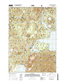
2014 Map of Davis Mountain
USGS Topo · Published 2014About this map
The Deschutes National Forest dominates this landscape, where the high volcanic terrain of the Cascade Range meets an intricate network of waterways and timber access roads. High-elevation hydrology is the defining characteristic of this area, anchored by the expansive Wickiup Reservoir and the northern shores of Davis Lake. The map illustrates the varied aquatic environments of the region, from the smaller alpine basins of N Twin Lake and S Twin Lake to the drainage of Browns Cr and Moore Cr. Prominent volcanic landmarks such as Davis Mountain, Browns Mtn, and Pine Butte rise above the forest floor, connected by a web of Forest Service routes like the Pine Butte Loop and Davis Mtn Lookout Rd. This 2014 survey serves as a precise guide to the modern recreational and resource management infrastructure within this section of the Oregon Cascades.
Find a feature on this map
38 named features on this map. Tap any name to fly to it.
Don’t see what you’re looking for? This feature index may not catch every label — zoom into the map to look around manually.
Map Details
Editions of this 2014 Davis Mountain Map
This is the sole edition of this map. No revisions or reprints were ever made.
Other maps of this area

1930 · Maiden Peak
USGS Topo · 1:125,000

1934 · Maiden Peak
USGS Topo · 1:125,000

1955 · Crescent
USGS Topo · 1:250,000

1957 · Crescent
USGS Topo · 1:250,000

1958 · Crescent
USGS Topo · 1:250,000

1963 · Round Mountain
USGS Topo · 1:24,000

1963 · Hamner Butte
USGS Topo · 1:24,000
1963 · The Twins
USGS Topo · 1:24,000
1963 · Odell Lake
USGS Topo · 1:24,000
1963 · Irish Mountain
USGS Topo · 1:24,000