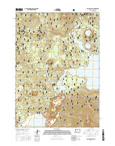
2017 Map of Davis Mountain
USGS Topo · Published 2017About this map
Deschutes National Forest encompasses this high-elevation landscape, where the volcanic peaks of the Cascade Range give way to a complex network of forest roads and alpine water bodies. The geography is defined by the significant presence of Davis Lake in the south and the sprawling reach of the Wickiup Reservoir to the east. These waters are connected by a web of seasonal tracks and trails, including the Hammer-Davis Run and the Davis Lake Run, which traverse the timbered slopes between Davis Mtn and Pine Butte. The map reveals a land managed for both recreation and resource protection, illustrated by the numerous National Forest Development roads and the inclusion of smaller, distinct basins like N Twin Lake and S Twin Lake near the northern boundary. This 2017 survey serves as a detailed record of the access points and topographic landmarks within the eastern Cascades' volcanic interior.
Find a feature on this map
51 named features on this map. Tap any name to fly to it.
Don’t see what you’re looking for? This feature index may not catch every label — zoom into the map to look around manually.
Map Details
Editions of this 2017 Davis Mountain Map
This is the sole edition of this map. No revisions or reprints were ever made.
Other maps of this area

1930 · Maiden Peak
USGS Topo · 1:125,000

1934 · Maiden Peak
USGS Topo · 1:125,000

1955 · Crescent
USGS Topo · 1:250,000

1957 · Crescent
USGS Topo · 1:250,000

1958 · Crescent
USGS Topo · 1:250,000

1963 · Round Mountain
USGS Topo · 1:24,000

1963 · Hamner Butte
USGS Topo · 1:24,000
1963 · The Twins
USGS Topo · 1:24,000
1963 · Odell Lake
USGS Topo · 1:24,000
1963 · Irish Mountain
USGS Topo · 1:24,000