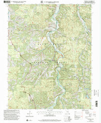
1999 Map of Davisville
USGS Topo · Published 2002About this map
Huzzah Creek meanders through the central corridor of this Crawford County landscape, defining a topography of steep hollows and ridges within the Mark Twain National Forest. The settlement of Davisville sits at a bend in the creek, serving as a focal point for the surrounding rural valley. The map reveals a dense network of family-named landmarks and ancestral sites, including the Pyatt Cem, Skaggs Cem, and Donhammer Cem, which are scattered among the timbered hills.
Find a feature on this map
50 named features on this map. Tap any name to fly to it.
Don’t see what you’re looking for? This feature index may not catch every label — zoom into the map to look around manually.
Map Details
Editions of this 1999 Davisville Map
This is the sole edition of this map. No revisions or reprints were ever made.
Other maps of this area

1932 · Steelville
USGS Topo · 1:48,000

1933 · Steelville
USGS Topo · 1:62,500

1937 · Steelville
USGS Topo · 1:62,500

1941 · Stone Hill
USGS Topo · 1:62,500

1943 · Berryman
USGS Topo · 1:62,500

1943 · Boss
USGS Topo · 1:62,500

1945 · Stone Hill
USGS Topo · 1:62,500

1945 · Berryman
USGS Topo · 1:62,500

1946 · Boss
USGS Topo · 1:62,500

1949 · Rolla
USGS Topo · 1:250,000