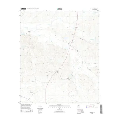
2014 Map of Davisville
USGS Topo · Published 2014About this map
Us-29 serves as the primary artery through this portion of Macon County, connecting the rural communities of Mount Andrew, Davisville, and Cotton Valley. The landscape is defined by the winding paths of Calebee Cr and Persimmon Cr, which feed into several small bodies of water including Lake Russell and Lake Wadsworth. This area preserves a significant genealogical record through its numerous community burial grounds, such as Shiloh Cem, Mt Nebo Cem, and Liberty Hill Cem, which are often the last standing indicators of earlier settlement clusters.
Find a feature on this map
55 named features on this map. Tap any name to fly to it.
Don’t see what you’re looking for? This feature index may not catch every label — zoom into the map to look around manually.
Map Details
Editions of this 2014 Davisville Map
This is the sole edition of this map. No revisions or reprints were ever made.
Other maps of this area

1955 · Phenix City
USGS Topo · 1:250,000

1957 · Phenix City
USGS Topo · 1:250,000

1958 · Phenix City
USGS Topo · 1:250,000

1971 · Little Texas
USGS Topo · 1:24,000

1971 · Tuskegee
USGS Topo · 1:24,000

1971 · La Place
USGS Topo · 1:24,000

1971 · Hardaway
USGS Topo · 1:24,000

1971 · Thompson
USGS Topo · 1:24,000
1973 · Union Springs
USGS Topo · 1:24,000
1973 · Roba
USGS Topo · 1:24,000