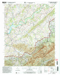
2003 Map of Davy Crockett Lake
USGS Topo · Published 2004About this map
The Nolichucky River carves through the heart of Greene County at the turn of the 21st century, its course marked by the Nolichucky Dam and the formation of Davy Crockett Lake. This landscape is defined by the sharp transition from the river valley's agricultural bottomlands to the steep rises of Chuckey Mountain and the Cherokee National Forest. Historically significant transportation routes like the Old Asheville Road and Stagecoach Road follow the contours of the terrain, connecting small rural centers such as Whitesand and Hayesville. The map captures a high density of community institutions in this Appalachian corridor, including Bernard Chapel, Beersheba Ch, and the Unaka Sch. The inclusion of Staunton Mill and numerous gaps like Cutshaw Gap and Kelly Gap illustrates how natural topography dictated early settlement and industry in this border region between Tennessee and North Carolina.
Find a feature on this map
68 named features on this map. Tap any name to fly to it.
Don’t see what you’re looking for? This feature index may not catch every label — zoom into the map to look around manually.
Map Details
Editions of this 2003 Davy Crockett Lake Map
This is the sole edition of this map. No revisions or reprints were ever made.
Other maps of this area

1892 · Greeneville
USGS Topo · 1:125,000

1894 · Asheville
USGS Topo · 1:125,000

1896 · Greeneville
USGS Topo · 1:125,000

1901 · Asheville
USGS Topo · 1:125,000

1904 · Greeneville
USGS Topo · 1:125,000

1935 · Paint Rock
USGS Topo · 1:24,000

1935 · Mosheim
USGS Topo · 1:24,000

1935 · Cedar Creek
USGS Topo · 1:24,000

1935 · Hot Springs
USGS Topo · 1:24,000

1936 · Greystone
USGS Topo · 1:24,000