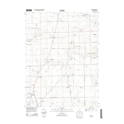
2013 Map of Dawn
USGS Topo · Published 2013About this map
Agricultural life in Darke County, Ohio, is defined by the tight-knit network of family-run operations and small townships that populate this landscape. The Stillwater River meanders through the central terrain, providing a natural drainage corridor for many tributary creeks including Indian Cr and Boyd Cr. Notable rural settlements like Beamsville, Stelvideo, and Frenchtown serve as anchors for the surrounding farmland. Genealogists will find a significant concentration of burial grounds, such as Wakefield Lutheran Cem and the Saint Johns Lutheran Cem, which indicate the long-standing heritage of the local Lutheran community. The presence of specialized facilities like the Marshal Poultry Farm and Schrader Dairy Farm highlights the intensive livestock and poultry industries that have long supported the local economy. Aviation landmarks such as the Darke County Airport and Trump Airport contrast with the traditional grid of township roads that follow historic section lines.
Find a feature on this map
95 named features on this map. Tap any name to fly to it.
Don’t see what you’re looking for? This feature index may not catch every label — zoom into the map to look around manually.
Map Details
Editions of this 2013 Dawn Map
This is the sole edition of this map. No revisions or reprints were ever made.
Other maps of this area

1908 · St. Henry
USGS Topo · 1:62,500

1909 · Loramie
USGS Topo · 1:62,500

1911 · Loramie
USGS Topo · 1:62,500

1911 · Covington
USGS Topo · 1:62,500

1944 · Covington
USGS Topo · 1:62,500

1944 · Loramie
USGS Topo · 1:62,500

1953 · Muncie
USGS Topo · 1:250,000

1956 · Muncie
USGS Topo · 1:250,000

1961 · Dawn
USGS Topo · 1:24,000
1961 · Greenville East
USGS Topo · 1:24,000