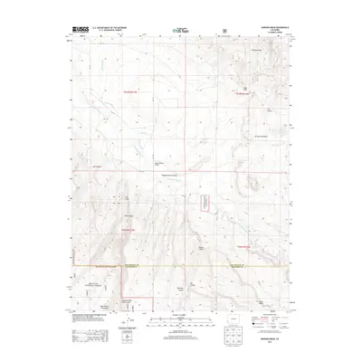
2013 Map of Dawson Draw
USGS Topo · Published 2013About this map
Disappointment Valley anchors this high-desert landscape along the border of San Miguel and Dolores counties. The 2013 survey illustrates the essential role of water management in this arid region, tracing the paths of the Horseshoe Ditch and Custer Ditch as they navigate the complex topography. While the area is largely defined by public lands, including portions of the Uncompahgre Nat For and San Juan National Forest, specific human landmarks like the Daddy Williams Bridge provide critical navigation points across Disappointment Cr. The map reveals a deeply eroded terrain characterized by named features such as Klondike Basin, Andy Draw, and Wolf Den Canyon, highlighting the geological complexity of the Colorado Plateau as it appeared in the early 21st century.
Find a feature on this map
32 named features on this map. Tap any name to fly to it.
Don’t see what you’re looking for? This feature index may not catch every label — zoom into the map to look around manually.
Map Details
Editions of this 2013 Dawson Draw Map
This is the sole edition of this map. No revisions or reprints were ever made.
Other maps of this area

1916 · Paradox Valley
USGS Topo · 1:125,000

1922 · Paradox Valley
USGS Topo · 1:125,000

1948 · Hamm Canyon
USGS Topo · 1:24,000

1948 · Gypsum Gap
USGS Topo · 1:24,000

1949 · Gypsum Gap
USGS Topo · 1:24,000

1949 · Joe Davis Hill
USGS Topo · 1:24,000
1950 · Hamm Canyon
USGS Topo · 1:24,000

1950 · Joe Davis Hill
USGS Topo · 1:24,000

1956 · Cortez
USGS Topo · 1:250,000

1956 · Moab
USGS Topo · 1:250,000