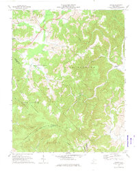
1971 Map of Dawson
USGS Topo · Published 1974About this map
The Meadow River and its tributaries carve a complex drainage pattern through the central West Virginia highlands in the early 1970s. This survey illustrates a landscape defined by prominent ridgelines such as Bennett Mountain and Blue Sulphur Ridge, which separate the various hollows and creek beds. The area is dotted with small rural communities and local landmarks, including the historic Blue Sulphur Springs and the settlement of Dawson. Numerous small country churches serve the scattered population, with Maude Chapel, McElhenney Ch, and Chapel Hill Ch marking social centers of the day. In the southern portion of the quadrangle, the terrain rises significantly toward Keeney Knob, where a Lookout Tower and Radio Tower stand as high-elevation landmarks along the Greenbrier and Summers county line.
Find a feature on this map
47 named features on this map. Tap any name to fly to it.
Don’t see what you’re looking for? This feature index may not catch every label — zoom into the map to look around manually.
Map Details
Editions of this 1971 Dawson Map
This is the sole edition of this map. No revisions or reprints were ever made.
Other maps of this area

1887 · Hinton
USGS Topo · 1:125,000

1892 · Hinton
USGS Topo · 1:125,000

1912 · Meadow Creek
USGS Topo · 1:48,000

1912 · Big Bend
USGS Topo · 1:62,500

1914 · Big Bend
USGS Topo · 1:62,500

1915 · Meadow Creek
USGS Topo · 1:62,500

1921 · Alderson
USGS Topo · 1:48,000

1921 · Clintonville
USGS Topo · 1:48,000

1923 · Clintonville
USGS Topo · 1:62,500
1923 · Alderson
USGS Topo · 1:62,500