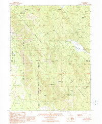
1990 Map of Day
USGS Topo · Published 1990About this map
Day serves as a central reference point in this corner of the California high country, situated where the boundaries of Modoc, Shasta, and Lassen counties converge. The landscape is defined by the massive Big Valley Mountains, which dominate the central and southern portions of the map. High-elevation peaks such as Widow Mountain and Jimmerson Mountain overlook a network of seasonal water sources and basins, including Sugar Pine Basin and Widow Valley.
Find a feature on this map
30 named features on this map. Tap any name to fly to it.
Don’t see what you’re looking for? This feature index may not catch every label — zoom into the map to look around manually.
Map Details
Editions of this 1990 Day Map
This is the sole edition of this map. No revisions or reprints were ever made.
Other maps of this area

1886 · Modoc Lava Bed
USGS Topo · 1:250,000

1892 · Modoc Lava-Bed
USGS Topo · 1:250,000

1954 · Alturas
USGS Topo · 1:250,000

1958 · Alturas
USGS Topo · 1:250,000

1961 · Bieber
USGS Topo · 1:62,500

1961 · Fall River Mills
USGS Topo · 1:62,500

1962 · Alturas
USGS Topo · 1:250,000

1962 · Crank Mountain
USGS Topo · 1:62,500

1962 · White Horse
USGS Topo · 1:62,500

1965 · Alturas
USGS Topo · 1:250,000