1957 Map of Dayton
USGS Topo · Published 1978About this map
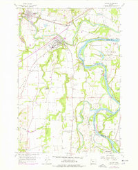
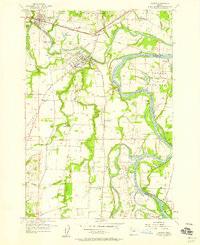
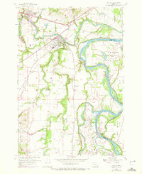
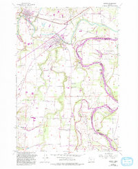
The confluence of the Yamhill River and the Willamette River anchors this mid-century look at Yamhill County. The landscape is defined by the fertile flats of Dayton Prairie and French Prairie, where agriculture and river-based transport have long intersected. The settlement of Dayton sits prominently near the river bend, while the historical importance of water navigation is evidenced by numerous river features like San Salvador Beach, Candiani Bar, and Weston Landing.
Find a feature on this map
62 named features on this map. Tap any name to fly to it.
Don’t see what you’re looking for? This feature index may not catch every label — zoom into the map to look around manually.
Map Details
Editions of this 1957 Dayton Map
4 editions found
Other maps of this area

1916 · Tualatin
USGS Topo · 1:62,500

1923 · Mount Angel
USGS Topo · 1:62,500

1924 · Mc Minnville
USGS Topo · 1:48,000

1926 · Mc Minnville
USGS Topo · 1:62,500

1939 · Tualatin
USGS Topo · 1:62,500

1940 · McMinnville
USGS Topo · 1:62,500

1940 · Tualatin
USGS Topo · 1:62,500

1940 · Mount Angel
USGS Topo · 1:62,500

1941 · Yamhill
USGS Topo · 1:62,500

1942 · Yamhill
USGS Topo · 1:62,500