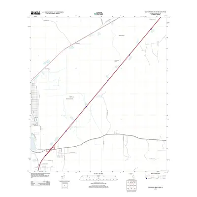
2012 Map of Daytona Beach SW
USGS Topo · Published 2012About this map
Lake Winnemisett and its surrounding residential streets anchor the southwestern portion of this Volusia County landscape, where the modern interstate and local road networks intersect. The area exhibits a transition from dense suburban plotting, visible along the grid of 8th Ave and E Pkwy, to the more expansive wetlands and hammocks characteristic of the Florida interior. Low-lying terrain is punctuated by named rises such as McKenzie Islands, Rattlesnake Island, and Dukes Islands, which emerge from the surrounding marshy topography. To the north, Sunset Memorial Park provides a large, dedicated space, while the presence of Coe Field Airport in the southeast highlights the importance of light aviation to the regional infrastructure. This 2012 survey captures a moment of established development alongside the persistent natural features of the flatwoods, including the historic routes like Old Sawmill Rd.
Find a feature on this map
37 named features on this map. Tap any name to fly to it.
Don’t see what you’re looking for? This feature index may not catch every label — zoom into the map to look around manually.
Map Details
Editions of this 2012 Daytona Beach SW Map
This is the sole edition of this map. No revisions or reprints were ever made.
Other maps of this area

1952 · Samsula
USGS Topo · 1:24,000

1952 · Daytona Beach
USGS Topo · 1:24,000

1954 · Daytona Beach
USGS Topo · 1:250,000

1955 · Orlando
USGS Topo · 1:250,000

1957 · Orlando
USGS Topo · 1:250,000

1958 · Orlando
USGS Topo · 1:250,000

1958 · Daytona Beach
USGS Topo · 1:250,000

1962 · Orlando
USGS Topo · 1:250,000

1962 · Daytona Beach NW
USGS Topo · 1:24,000

1962 · Daytona Beach SW
USGS Topo · 1:24,000